Iceland eruptions

Iceland is twice blessed--or cursed, depending on your perspective.
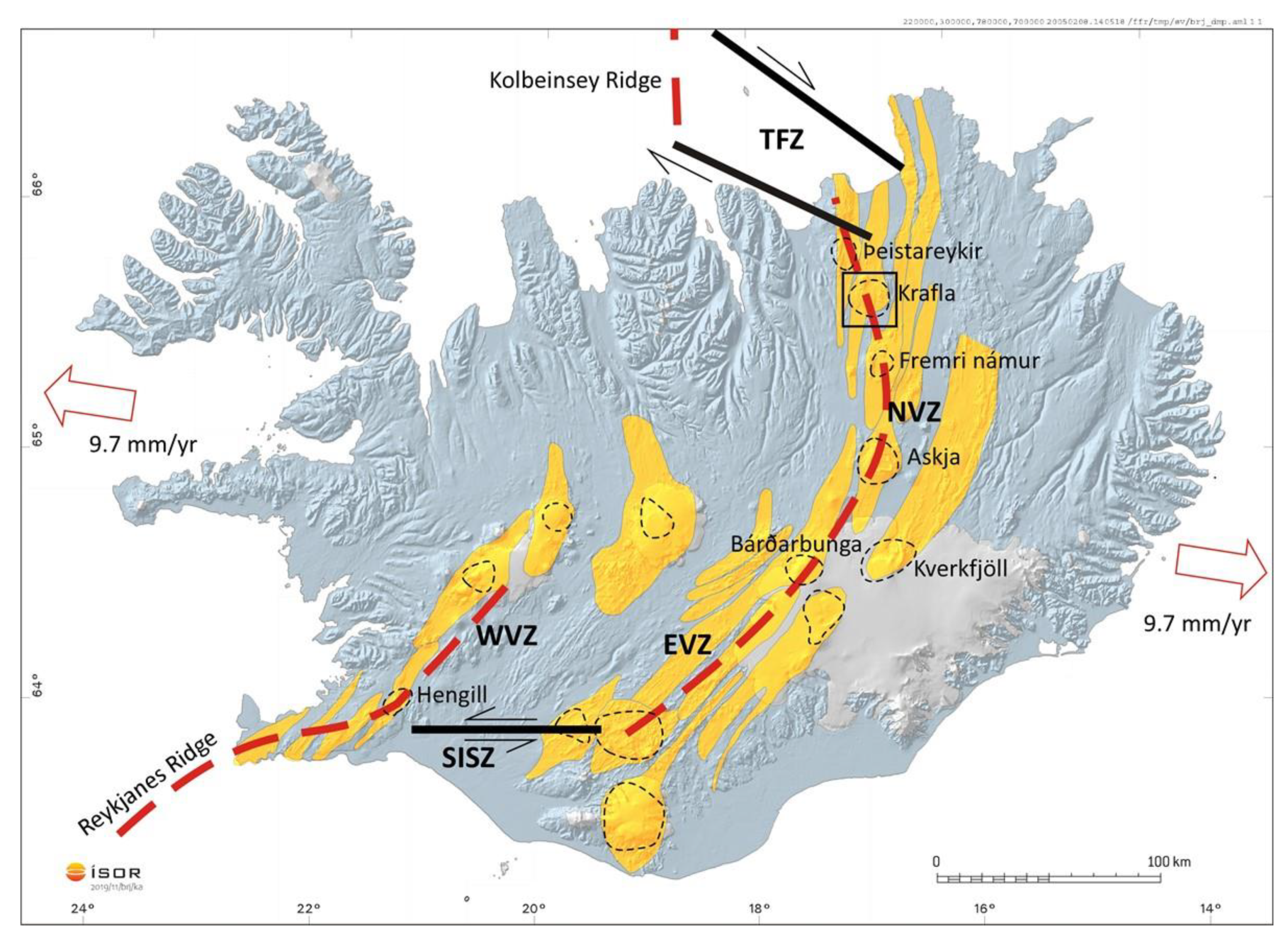
geosciences-10-00034-g001.png


Not only does it sit atop a plate boundary, but it also sits over a magmatic hotspot.

Not quite like pitching your tent on a super highway---------------but...............................
 
This article gives a summary.

Iceland appears to be in a cycle which could be devastating for the region. Heat and housing has already been affected.
A human and science story here.

https://phys.org/news/2024-02-unprecedented-magma-river-surged-beneath.html
Yes I’ve been following this since the Fagradalsfjall eruption a couple of years ago. A series of fissure eruptions, minor in themselves but close to human habitation. Grindavik, which is now evacuated and may have to be abandoned, is a fishing port with a fish processing industry that is quite important to the economy of Iceland. And Reykjavik is not far away - the eruptions can be seen from the city at night. There are a lot of YouTube videos put up by various Icelanders, some of whom fly drones, that are quite informative about the situation.
 
Yes I’ve been following this since the Fagradalsfjall eruption a couple of years ago. A series of fissure eruptions, minor in themselves but close to human habitation. Grindavik, which is now evacuated and may have to be abandoned, is a fishing port with a fish processing industry that is quite important to the economy of Iceland. And Reykjavik is not far away - the eruptions can be seen from the city at night. There are a lot of YouTube videos put up by various Icelanders, some of whom fly drones, that are quite informative about the situation.
I recommend Professor Shawn Willsey, he gives updates based on met/GPS data, seismic data.
The drone stuff on the ground is interesting from the locals (prof Willsey has used of one also) but in terms of what is going on under ground a geologist is what you need.

This is a discussion with fellow geologist from Iceland.

 
Time stamp of the conversation.

0-7.49: Geology, tectonics and volcanic activity of the peninsula and rest of Iceland.


7.49: Current state. Seismic activity related to the eruptions. Different "systems" across Iceland. Comparison to Hawaii.


14.12: Can previous crater systems in the area re-open?


18.20: Rock composition role, bore hole data.


23.57: Reaction to the emergency, mitigation and preparations.


32:40: Iceland volcanic misconceptions and what could happen next.
 
I recommend Professor Shawn Willsey, he gives updates based on met/GPS data, seismic data.
The drone stuff on the ground is interesting from the locals (prof Willsey has used of one also) but in terms of what is going on under ground a geologist is what you need.

This is a discussion with fellow geologist from Iceland.

Oh yes , I’ve seen a very informative one he did on the Salton Sea in California. I might look at this one later if I have a moment.
 
Time stamp of the conversation.

0-7.49: Geology, tectonics and volcanic activity of the peninsula and rest of Iceland.


7.49: Current state. Seismic activity related to the eruptions. Different "systems" across Iceland. Comparison to Hawaii.


14.12: Can previous crater systems in the area re-open?


18.20: Rock composition role, bore hole data.


23.57: Reaction to the emergency, mitigation and preparations.


32:40: Iceland volcanic misconceptions and what could happen next.
The main thing I got out of it was that the eruptions are occurring on the East flank of the zone of uplift. They could also take place on the West, where the Eldvörp craters are, but unlikely to erupt in the middle, as there seems to be an area of more resistant rock there.

I was also interested to learn that the magma reservoirs are in the crust in Iceland, whereas in Hawaii they are actually within the volcanoes, closer to the surface.

There is an interesting scientific story there but obviously a human element.
The geologists are saying this is increasing looking like a cycle after a period of dormancy of 800 years or so.
Let's see how it goes next two weeks.

If you are interested the live updates are very good and you can ask questions in chat, Shawn attempts to answer all of them at the end.

I have cited the site on here and Physics Forums as I think it is that good.

YouTube I do not usually recommend for science but this is an exception.
This guy Just Icelandic is quite good for short 10 min bursts on what's going on, in a mix of vulcanology and social issues: https://www.youtube.com/@JustIcelandic
He quite often flies a drone and shows maps of the area, which is helpful.
 
As/re the linked video from #5:
Here is a likely image of the icelandic plume
upload_2024-2-26_13-7-32.jpeg

one deep tomographic impression seems to indicate that Iceland is currently north west of the base of the plume which may have left volcanic matter across Greenland?
 
Last edited:
The next eruption is imminent according to Prof Willsey although a few sources were saying last week. We are over a month from the last event.
 
Still going strong at 2130GMT 20th March. Live cameras here:


It's come down from a long fissure to a line of vents but still pretty active. Luckily the authorities have had time to build protecting bunds at the right spots to deflect the flow past the power station and around Grindavik.
 
Geologist Prof Wilsey made a video and I have time stamped it. I recommend you watch all of it because he uses the same format which enables students and interested others (me) to pick up decent information. He has just returned from Iceland and saw some of this from a distance, public and other scientists were restricted access due to safety.

Intro.

3.57 Met office maps, location of the eruptions this year, town, blue lagoon and defences.

8.34 Met office updates, time lines, eruption status, lava flow rates, flow field map and pollution status.

13.06 Fixed drone image, full 360 Deg of the area.

15.37 Video footage.

19.00 Spectacular ground water magma explosions.

23.00 Power lines on fire.

24.00 Eruptions as it happened in real time, actual event is 25.55.

 
Back
Top